This post probably contains affiliate links. This means that you still pay the same price, but we earn a small commission. As an Amazon Associate, we earn from qualifying purchases. We only ever link products that we have tried and can recommend with confidence. These items are Nirvana Girl approved! We always appreciate your support in our journey!
Last summer I did my first ever backpacking trip! My best friend and I decided on hiking Skyline trail in Jasper. I did a lot of research before settling on this hike. There are a couple reasons this one was my top choice. Firstly, it was touted as one of the best views to effort ratio hikes in Alberta. Secondly, we could park at the bottom and take a shuttle to the top. Thirdly, I read that there was an abundance of streams and creeks so we wouldn’t have to pack all our water.
Bookings:
Bookings for the hike opened in January, and I was up at 6:00 AM the day bookings opened in order to secure a permit. You can check the Parks Canada site for the specific day it opens as it may change from year to year. This is one of the most popular trails in Jasper, and people come from international destinations to hike it. This year I decided post-COVID to just check and see if I could get a couple spots, and it was full every single day of the season! This link was very helpful in sharing the rules, recommended itineraries, and other important information regarding the hike. https://www.pc.gc.ca/en/pn-np/ab/jasper/activ/passez-stay/arrierepays-backcountry/sugg-sentiers_trip-ideas/Skyline The best time to hike Skyline trail, Jasper is late July through early September. I believe it’s open longer than that but I don’t fancy hiking through more terrible weather and snow than strictly necessary!
Getting to the trailhead:
Now we live in the Edmonton area, which means we had to drive down the night before in order to meet the shuttle first thing in the morning. We elected to drive to Hinton after work, and park in a parking lot to sleep. The Freson Brothers in Hinton are nice enough to have a large sign saying RV camping welcome, so we had plenty of company and felt very safe and relaxed. In the morning we helped ourselves to the washrooms, bought ourselves some Starbucks, and headed into Jasper.
We stopped at the visitor centre washrooms to enjoy one final real washroom, ate the overnight oats we packed for breakfast and then drove to the end of the hike. We saw several other groups waiting for the shuttle so we were reassured that we were in the right place. This is the link I used to book our shuttle ride up to the top of Maligne lake to start the hike! https://maligneadventures.com/sightseeing/
Starting at the top:
Now we chose to start the hike from the “Top” because that is the direction with less uphill hiking. Now don’t get me wrong, you are going up and down mountains, and there’s still plenty of uphill, but after doing the hike I am definitely glad I did it from Maligne lake down towards Jasper. We got to the end of the ride, and made our way to the trailhead. We exchanged photo taking opportunities with some of the other hikers so that everyone got a pic in front of the sign, then started the hike!


Deceiving beginnings:
The trail starts out in a lovely wooded area, before starting the incline. You soon encounter switchbacks, and a lot of them. Pay attention here because you might hate them now but later you will think back fondly on that time when you weren’t hiking straight up! The forest is lovely and we passed a few ponds and some streams before arriving at the first large bridge. We elected to pass the first campgrounds Evelyn Creek and Little Shovel when planning the hike since it’s only a few km from the start of the hike.
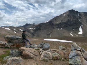
Eventually you start to clear the treeline and the real views begin. The trail straightens out as you wander along the treeline until eventually you end up in the first of many mountain valleys. The sun was shining, the wildlife was out, the birds singing and the pekkas squeaking! But seriously the flora and fauna are magical, and it is so quiet up there. It’s a surreal experience I think everyone should enjoy at least once.
As you make your way along the valley and up into the next one, your legs are probably going to start getting tired. But you have a few more valleys to go before you reach Snowbowl campsite, which is where we elected to rest our heads. It’s nestled down in a beautiful verdant green valley, with amazing views that go forever. I seriously can’t properly describe the views, and pictures don’t do it justice. We reached the site with relief and set up our campsite.
The Sites:
The sites are well equipped, and you have to use the provided tent pads, but it’s first come first dibs for the nicer sites. There is an area with picnic tables for eating, and bear lockers for storing food overnight. Also they have outhouses! Yay! Who thought we would be excited about outhouses? But be warned, these are not regular outhouses. These are sets of three seats, open to the fresh air. I mean you have zero privacy but incredible views, so I like to think it’s worth it.
Anyways we set ourselves up, and proceeded to get our dinner ready at the picnic tables. Some other hikers were nice enough to share half a table with us so we could boil the water for our pad thai, and we got to chat and learn from some more experienced backpackers as they told us stories and recommended hikes. I can’t say this enough, everyone was friendly, helpful, and cheerful. I loved the sense of community we found with a bunch of strangers, it was very comforting to know they would totally be the kind of people to stop and help if you need it. We spent some time chatting and then headed for our tent.
We tried pretty hard to stay awake but the lure of our sleeping bags proved too hard to resist. After a few yoga poses and stretches to help recover from our first day we crashed early. Ridiculously early. I’m pretty sure it wasn’t even 8:00. We slept for a solid 12 hours.


Day two:
The next morning we were one of the last ones up. We stumbled out to the bear lockers, grabbed our breakfast, and made the coffee. My friend had decided to bring overnight oats and have a cold breakfast. I on the other hand love a warm breakfast while camping, so I boiled water for the coffee and my oatmeal. Looking back I have realized that for the sake of both efficient mornings and fuel, that I am more than ok with just hot coffee and a cold breakfast. I also realized we should have gotten up and moving a bit earlier that morning. The second day is the longest and hardest of the three.
We packed up and headed out by around 9:00 that morning. Continuing to hike through mountain valleys and making our way upwards. We climbed all the way up to a pass, then hiked along a ridgeline. Again it was an amazing experience, with a sightline along the valley for miles. We tried to capture it with pictures but you should definitely go see it for yourself! We hiked along the ridge for a very long way before spotting the Curator campground in the distance.
This was also the random spot we got cell service. We laughed exceedingly hard at the fact that we could get cell service a day and a half into the back country with no signs of civilization for miles. I sent my mom a quick text that we were doing well and that I was standing on top of a mountain.
The Notch:
Since we weren’t staying at Curator campground, we didn’t bother detouring down into the valley. Eventually we came into sight of the Notch. Now I had heard about it and read about it, but I was not prepared. This thing was huge! Now we were getting tired, and it was after lunch. This is the exact spot I realized we should have left earlier. We still had 10 km to go. The Notch is the highest point on the trail at 2400m elevation. And we had to climb it.
This is where you start seeing snow. This is also where the clouds started coming in. As we climbed, the weather kept getting worse. We watched the clouds roll in and kept climbing. By the time we reached the highest point in the trail you couldn’t see more than 10 meters in front of you. We were in the clouds and it was surreal. Our sense of victory didn’t last long.


The ridgeline:
What should have been the easiest part of the day with some of the best views, turned into a race against the weather. We started getting rained on, then the tiny hail started. As we were trudging along the ridgeline, we heard thunder. We sped up. The thunder kept getting closer, the rain was soaking us, and we kept going faster. The idea of standing on top of a mountain in a thunderstorm did not appeal to us. So we hoofed it. Booked it. Made tracks. Until the storm finally passed and we could relax. But now we were soaking wet, and freezing cold.
As long as we kept moving we were ok, but we really wanted to get to our campsite by this point. We still had a long way to go, so we kept trudging. We made sure to drink lots of water and ate lots of snacks to keep us going, but the adrenaline had worn off and we were tired.


By the time we reached Tekarra campsite, set up our tent, and ate a hasty dinner we were done with that day. As I was running our food down to the bear lockers a couple of other hikers commented they were glad to see us. They had been wondering where we were. This was so comforting and reassuring. We cleaned up as best we could, climbed into our (thankfully) warm, dry sleeping bags, and crashed. I don’t think it was even 7:00.
Day three:
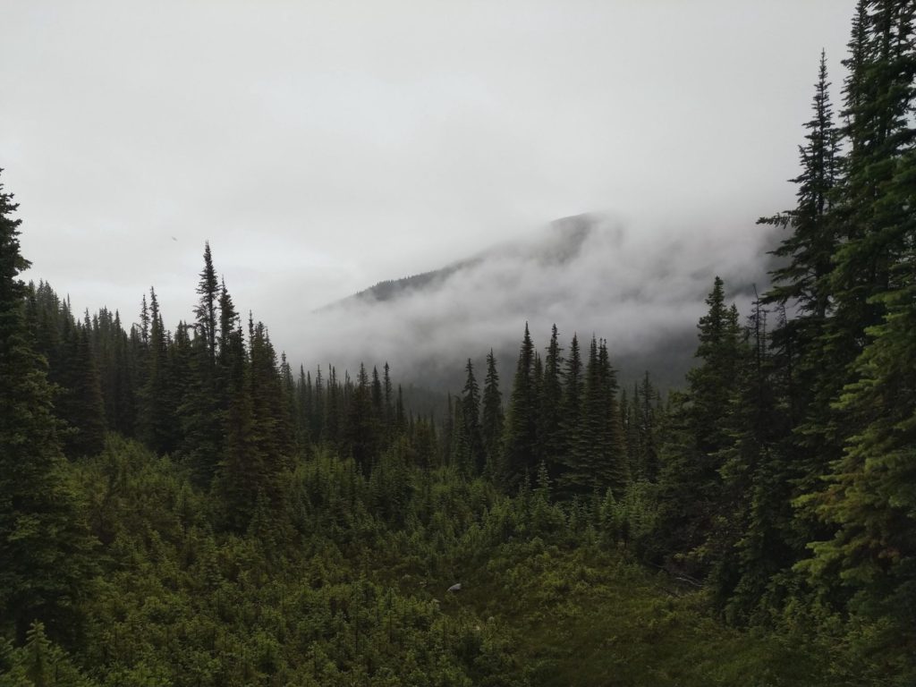
The next morning it was still raining. We said fuck it, ate protien bars for breakfast, packed up and headed out. It was 6:30 AM and we wanted to be warm and dry in our car! As we hiked out we enjoyed the foggy, cloudy morning. The views might not have been as spectacular but the magical atmosphere was something else. This is where I took the picture for the header of our blog! It was one of the only photos we took that day.
We steadily descended towards the end of the hike. Eventually we made it to the fire road at the end of the trail, which would take us down to the cars. We celebrated, we sped up, and we talked about the food we wanted to get at the drive through! Then we kept hiking, and hiking, and hiking. I was about ready to cry after a couple hours of hearing the traffic from the road and not seeing the end of the hike.
Eventually a couple of hikers we had talked to the first day caught up with us and chatted. Then my friend who was ahead by this point turned and threw her hands up in the air smiling. I yelled “Are you fucking serious?” The other hikers laughed as we celebrated the end of the trail. We stopped and got A&W on the way home.
Lessons learned on this hike:
- Start early in the morning.
- Bring tons of snack food.
- Don’t listen to the people on youtube who say you don’t need to buy a backpack cover, you can simply line your pack with a garbage bag to keep your stuff dry.
I ate so many protein bars, dried fruit, candy, and stinger waffles this hike that I was amazed. I am so thankful that I listened to the bloggers who advocated for bringing an extra day’s worth of food. Also just because your sleeping gear stays dry doesn’t mean you’re soaking wet backpack won’t end up weighing almost double what it did when you started. And sleeping in dry long underwear is as close to heaven as you get on the trail when it’s raining. (If you want more details on what gear worked vs. what didn’t click here!)
Hiking Skyline trail, in Jasper I learned that for my next trip I want a backpacking pillow, and a lighter sleeping pad then the one I made do with this time. As we headed home I swore up and down that I wasn’t going to take another trip, and in the same breath started planning all the things I want to change or do better on the next trip. And dammit I want to actually see the views from the top of the notch next time!
If you are looking for a day hike in Jasper, check out our post on hiking Wilcox Pass here.